
Between rubble and riverbeds: Rebuilding after the DANA floods in Valencia
We were standing on a road in Picanya, a town south of Valencia, one year after the storm that changed it forever. On one side of us, a dry riverbed; on the other, the rubble of collapsed houses. We stood on the tiled floor of what had once perhaps been a kitchen. On the remaining walls, dried mud clearly traced the water level, three to four metres high, nearly to the ceiling.
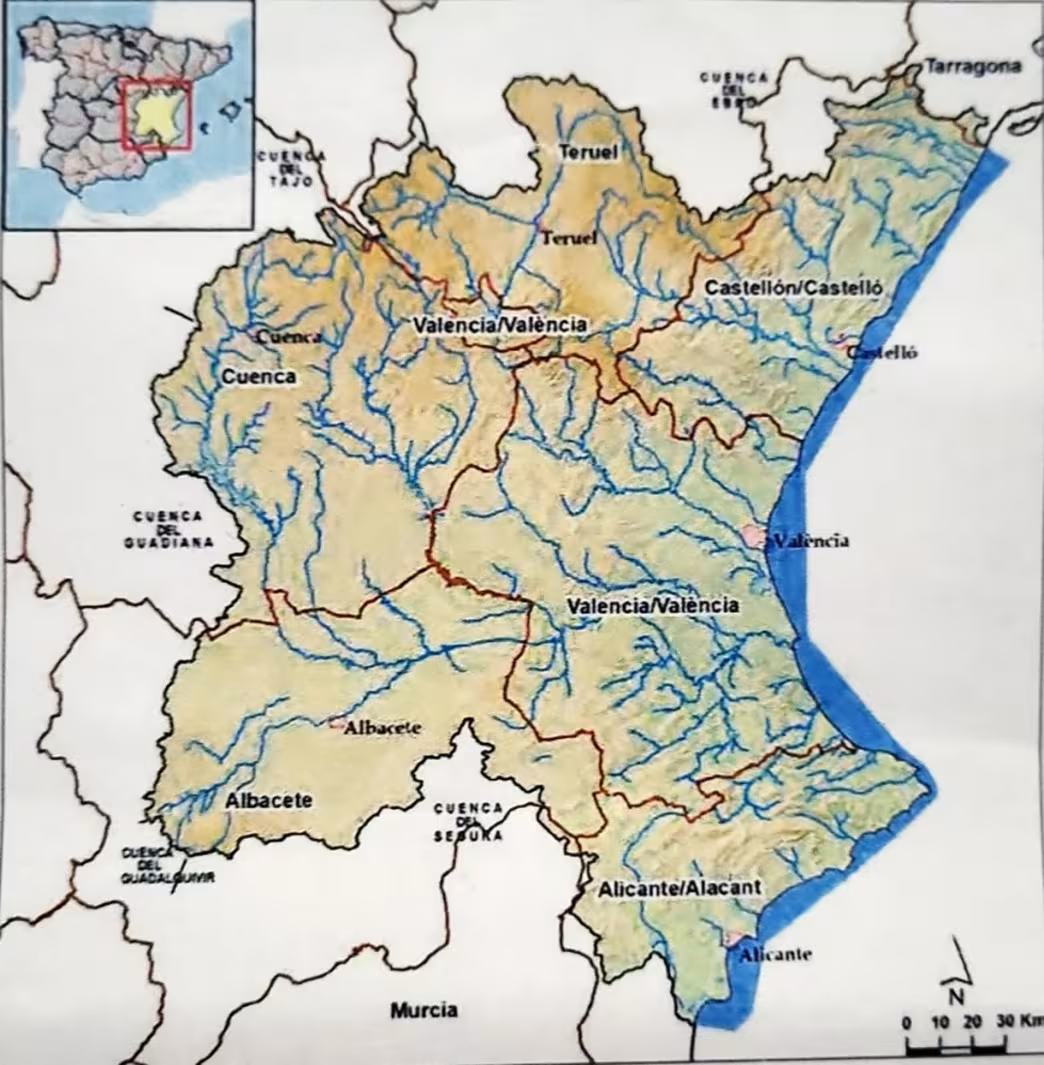
Map of area managed by the CHJ (Júcar River Hydrographic Confederation), covering a total surface area of 43,000 km2, comprising numerous basins. The main flood in this episode have occurred in the Turia, Magro and Poyo rivers. Source: chj.es
It had arrived without warning on 29 October 2024, transforming quiet streets into rivers and fields into lakes. An intense DANA (an Isolated Depression at High Levels, or gota fría) swept across the Valencian Community, unleashing more than 600 millimetres of rain in just a few hours. In Picanya, one of the worst-hit towns south of Valencia, the torrent turned a modest ravine, the Poyo, a tributary of the Júcar River, into a roaring current: its flow was estimated to have reached more than 3,500 m³/s, far exceeding its usual capacity of 800 m³/s. It was hard to picture that the empty pit, now crossed by construction machinery, had overflowed with such force.
The Poyo Ravine basin is particularly prone to flooding because of its exposure to torrential rains, short runoff concentration time, lack of reservoirs, and dense land occupation. Picanya, being highly urbanized, is intersected by the Poyo right where the river narrows – creating a dangerous bottleneck.
While DANA is a natural atmospheric event specific to certain climatic conditions, that October 2024, its impact on Valencia was catastrophic, with exceptional rainfall and flooding drastically different from usual weather patterns, far exceeding what models had predicted or expected, and causing great loss and disruption.
The reconstruction phase
Besides Picanya, we also visited Torrent and Chiva. In all three towns, life seemed to have returned to some form of normalcy: people walked the streets or enjoyed their almuerzo in the sun. Yet in every place, a common soundtrack echoed: the music playing from radios on construction sites blending with the rumble of excavators and the rhythmic hammering. Trucks passed our group, shouting for us to move out of the way and some construction workers reminded us we really shouldn’t be standing there.
Now that the emergency phase has passed, the towns are working hard to reconstruct. The Júcar River Hydrographic Confederation (CHJ) faces the complex task of reshaping the hydrology of the river to better withstand future extremes. Plans include:
- Review hazard and risk maps
- Enforce stricter regulations in flood zones, e.g., improving the measures to self-protect urban areas, after an estimated 140,000 vehicles were declared unusable following the flood
- Adapt existing buildings to reduce vulnerability
- Implement engineering solutions such as connecting the Poyo Ravine to the Turia River, allowing excess water to be distributed during extreme events.
- Promote nature-based solutions (NBS) including forest zones for hydrological recovery, controlled storage areas, greenways to guide overflow, and improved waterway conditioning.
However, some of these solutions may involve land expropriation or forced changes in land use, which can trigger deep local conflicts. In Picanya, for instance, hand-painted banners hanging along the streets captured the tension with public critiques aimed at the local administration for expropriating “the most beautiful street in the city”. Such tensions highlight the challenge of balancing safety and identity: how to protect lives and livelihoods without erasing local heritage.
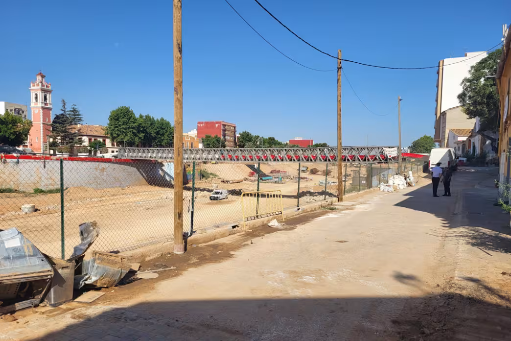
Photo of temporary bridge built by the military in Picanya, and behind new bridge under construction.
Photo by:
Cecilia Fraccaroli.
Looking forward
This extreme event was estimated to have the chance of it happening in any given year is roughly 1 in 2000 to 5,000 years, as a researcher at the Polytechnic University explained us. Although the probability sounds small, it is not fixed, especially with climate change.
We now face a paradox. On the one hand, hazard, the physical likelihood of a flood or storm causing damage, may be decreasing because of structural investments. On the other hand, vulnerability, the degree to which people and their assets are exposed, has been increasing. As a result, the potential for damage rises because of higher asset values and a false sense of safety provided by infrastructure, leading to riskier behaviour. This holds true not only for floods, but also for other disturbances such as wildfires.
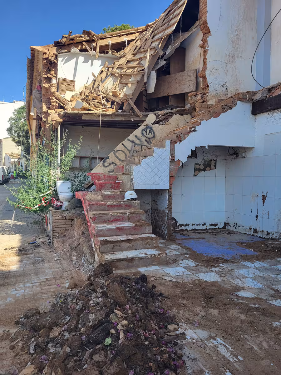
Photo of a building destroyed on the side of the river in Picanya.
Photo by:
Cecilia Fraccaroli.
As I walked through these towns, I couldn’t help but thinking of my current research on the rewilding of Gelderse Poort, in the Netherlands. In the 1990s, the area was hit by major floods. Since then, agricultural land has been transformed into wetlands, side channels, dunes, and riverine forests, now home to reintroduced semi-wild grazers and bursting with biodiversity. This project is a striking example of nature-based solutions (NbS), strategies that work with natural processes to manage water and support biodiversity. They can include restoring wetlands to absorb excess water, creating green corridors and floodplains, reforesting riverbanks, and designing urban parks that can double as water retention areas during high water periods.
While Gelderse Poort provides a useful illustration of what is possible when rivers are given more space, the social, environmental, and urban conditions of the Valencian plain are very different, shaped by intense urbanisation, agriculture, and the particular risks posed by DANAs. Exploring NbS here would require careful adaptation, combined with other measures such as early warning systems, emergency planning, and community engagement.
For the next few years or even generations, likely only smaller flood events would occur, and these can be better mitigated by the measures CHJ is now implementing. According to what the expert told us, nature-based solution can certainly make a difference for frequent, moderate flood events and high-water levels. But for events like the DANA in October 2024, they could perhaps reduce the extremely flooding impacts only by up to 20%: most damages would have happened anyhow.
Nature-based solutions are not a silver bullet. Extreme and unpredictable events will still cause damage, but preparedness can greatly reduce their impact. Education campaigns so people understand risks, early-warning systems that reach everyone in time, emergency drills to practise responses, and closer collaboration between scientists and local governments all play a crucial role. Ultimately, a cultural shift is needed: learning to live with water rather than fight against it.
This visit was made possible thanks to the guidance of the Júcar River Hydrological Confederation (CHJ) and the Polytechnic University of Valencia – IIAMA. The meeting took place as part of the Chinese National Development and Reform Committee (NDRC) delegation’s visit to Spain, organised by EFI (with support from the Eco2adapt project), ADB and CSIC.
This post is shared with the utmost respect and solidarity toward the local communities, civil protection teams, and CHJ staff who welcomed us during such a sensitive time.
Related content
The carob’s long shadow: from cursed tree to climate hero
The carob tree’s shift from a symbol of hardship and superstition to a climate‑resilient crop reflects evolving views on memory, culture, and value.
- Resilient forests

Mapping Lebanon’s hidden insect world, one barcode at a time
Lebanon DNA study of 58,000 insects finds over half the species may be unique to the Eastern Mediterranean.
- Resilient forests

ResAlliance
Engaging with farmers and foresters to share knowledge and increase landscape resilience in the Mediterranean.
- Resilient forests