G. J. Nabuurs, D. J. Brus, G. M. Hengeveld, D. J. J. Walvoort, P. W. Goedhart, A. H. Heidema, K. Gunia
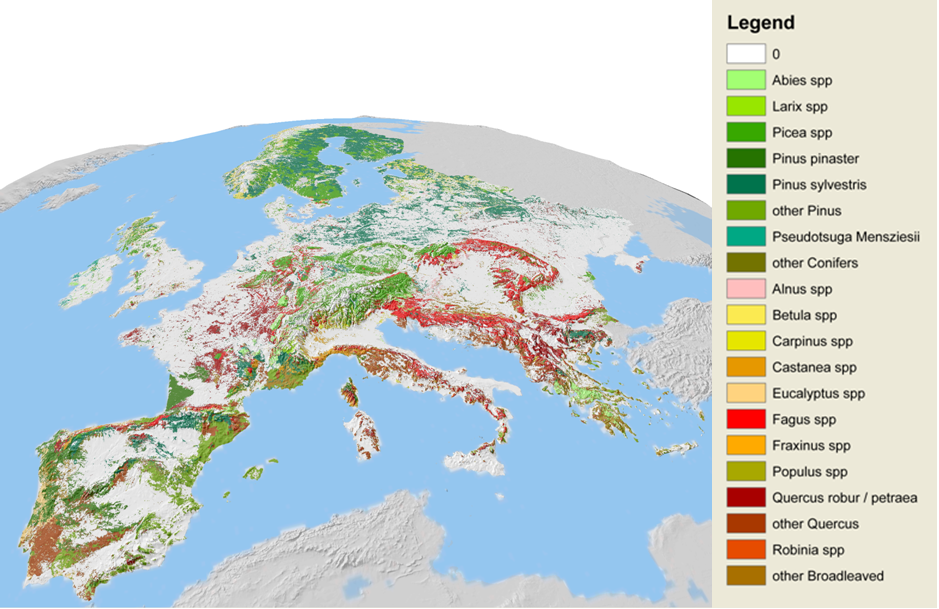
In cooperation with EFI, Alterra / Wageningen University and Research Centre has released a set of 1x1 km tree species maps showing the distribution of 20 tree species over Europe (Brus et al. 2011).
Basic dendrometric data were gathered for 260,000 national forest inventory plot locations from 17 countries (Nabuurs 2009). In areas with national forest inventory data, area proportions covered by the 20 species were obtained by compositional kriging. For the rest of Europe a multinomial logistic regression model was fitted to ICP-level-I plots using various abiotic factors as predictors (soil, biogeographical zones, bioindicators derived from temperature and precipitation data). The regression results were iteratively scaled to fit NUTS-II forest inventory statistics and the European Forest Map (Tröltzsch et al. 2009, Schuck et al. 2002). The predictions for the twenty tree species were validated using 230 plot data separated from the calibration. For more details please refer to Brus et al. 2011. Figure 1 demonstrates the aggregated results. Underlying GIS data are available for download from EFI website after short registration.
Disclaimer & acknowledgement
A user should realise that for some countries, at the national level, more accurate maps are available from the national forest inventories (NFI). The advantage of the current map lies in the European scale synchronization. None of the NFI’s can be held responsible for any wrong use of the data, information or results. We’re greatly indebted to the Forest Focus programme and the national forest inventory institute’s correspondents. Most of this work was carried out under Eforwood-IP, Carbo Europe IP, ADAM-IP and in connection to COST E43. The work was carried out by EFI and Alterra. NFI plot data were received from: Flanders and Walloon region of Belgium, Croatia, Estonia, Finland, France, Germany, five regional inventories of Italy, Lithuania, Netherlands, Norway, Portugal, Romania, Slovak Republic, Slovenia, Spain, Sweden, and the United Kingdom.
References
- Brus, D.J., G.M. Hengeveld, D.J.J. Walvoort, P.W. Goedhart, A.H. Heidema, G.J. Nabuurs, K. Gunia, 2011. Statistical mapping of tree species over Europe. European Journal of Forest Research 131 (1): 145–157.
- Hengeveld, G.M., G.J. Nabuurs, M. Didion, I. van den Wyngaert, A.P.P.M., Clerckx, M.J. Schelhaas, 2011. A forest management map of European forests. Ecology and Society. Special Issue Eforwood. In press.
- Nabuurs, G.J., 2009. NFI plot level database gathered from 18 European countries. Digital database. Alterra and European Forest Institute.
- Schuck, A., Van Brusselen, J., Päivinen, R., Häme, T., Kennedy, P., Folving, S., 2002. Compilation of a calibrated European forest map derived from NOAA-AVHRR data. EFI Technical Report 13, European Forest Institute.
- Tröltzsch, K., Van Brusselen, J., Schuck, A., 2009. Spatial occurrence of major tree species groups in Europe derived from multiple data sources. Forest Ecology and Management 257 (1): 294-302.
Contact
Sergey.Zudin(at)efi.int, Simo.Varis(at)efi.int